


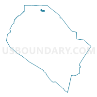
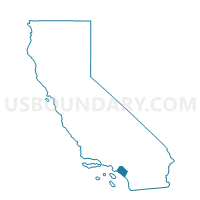
Voting District 34444, Orange County, California
About
Outline

Summary
| Unique Area Identifier | 536145 |
| Name | Voting District 34444 |
| County | Orange County |
| State | California |
| Area (square miles) | 1.02 |
| Land Area (square miles) | 1.02 |
| Water Area (square miles) | 0.00 |
| % of Land Area | 100.00 |
| % of Water Area | 0.00 |
| Latitude of the Internal Point | 33.90904500 |
| Longtitude of the Internal Point | -117.82294040 |
Maps

Graphs
Select a template below for downloading or customizing gragh for Voting District 34444, Orange County, California


Neighbors
Neighoring Voting District (by Name) Neighboring Voting District on the Map
- Voting District 30681, Orange County, CA
- Voting District 30766, Orange County, CA
- Voting District 33491, Orange County, CA
- Voting District 33496, Orange County, CA
- Voting District 34466, Orange County, CA
- Voting District 34471, Orange County, CA
- Voting District 34472, Orange County, CA
- Voting District 34473, Orange County, CA
- Voting District 34481, Orange County, CA
Top 10 Neighboring County Subdivision (by Population) Neighboring County Subdivision on the Map
Top 10 Neighboring Place (by Population) Neighboring Place on the Map
Top 10 Neighboring Unified School District (by Population) Neighboring Unified School District on the Map
- Placentia-Yorba Linda Unified School District, CA (154,626)
- Brea-Olinda Unified School District, CA (38,217)